


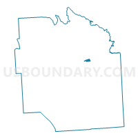
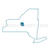
Voting District 180502, Onondaga County, New York
About
Outline

Summary
| Unique Area Identifier | 633068 |
| Name | Voting District 180502 |
| County | Onondaga County |
| State | New York |
| Area (square miles) | 0.58 |
| Land Area (square miles) | 0.58 |
| Water Area (square miles) | 0.00 |
| % of Land Area | 100.00 |
| % of Water Area | 0.00 |
| Latitude of the Internal Point | 43.05802750 |
| Longtitude of the Internal Point | -76.09526810 |
Maps

Graphs
Select a template below for downloading or customizing gragh for Voting District 180502, Onondaga County, New York


Neighbors
Neighoring Voting District (by Name) Neighboring Voting District on the Map
- Voting District 040007, Onondaga County, NY
- Voting District 040009, Onondaga County, NY
- Voting District 040014, Onondaga County, NY
- Voting District 040018, Onondaga County, NY
- Voting District 040022, Onondaga County, NY
- Voting District 180505 180607, Onondaga County, NY
- Voting District 180508, Onondaga County, NY
- Voting District 180510, Onondaga County, NY
- Voting District 180511, Onondaga County, NY
- Voting District 180610, Onondaga County, NY
- Voting District 181708, Onondaga County, NY
- Voting District 181710, Onondaga County, NY
- Voting District 181718, Onondaga County, NY
Top 10 Neighboring County Subdivision (by Population) Neighboring County Subdivision on the Map
Top 10 Neighboring Place (by Population) Neighboring Place on the Map
Top 10 Neighboring Unified School District (by Population) Neighboring Unified School District on the Map
- Syracuse City School District, NY (145,259)
- East Syracuse-Minoa Central School District, NY (22,315)
- Jamesville-DeWitt Central School District, NY (18,577)
Top 10 Neighboring State Legislative District Lower Chamber (by Population) Neighboring State Legislative District Lower Chamber on the Map
Top 10 Neighboring State Legislative District Upper Chamber (by Population) Neighboring State Legislative District Upper Chamber on the Map
Top 10 Neighboring 111th Congressional District (by Population) Neighboring 111th Congressional District on the Map
Top 10 Neighboring Census Tract (by Population) Neighboring Census Tract on the Map
- Census Tract 146, Onondaga County, NY (4,967)
- Census Tract 19, Onondaga County, NY (3,894)
- Census Tract 143, Onondaga County, NY (3,084)
- Census Tract 18, Onondaga County, NY (2,682)
- Census Tract 35, Onondaga County, NY (2,673)
- Census Tract 17.02, Onondaga County, NY (2,526)
- Census Tract 36.01, Onondaga County, NY (2,404)
- Census Tract 36.02, Onondaga County, NY (2,184)